
Big Bend Adventure
Public – We’ll have 5 days & 4 nights in Big Bend National Park to explore some of the most scenic country in Texas, heck, the world! We’ll be camping in the group campground in the Chisos Basin. We will have great access to showers, restrooms and all amenities. There’s an abundance of natural riches to explore inside the park and activities include hiking, paddling, rock climbing, mountain biking, horseback riding, wildlife viewing, stargazing, and even a day trip to sunny Mexico. Organized activities will get posted to the HTX/BCO calendar as we get closer to the trip date and we’ll also have signup sheets available for each day’s activities, the night before.
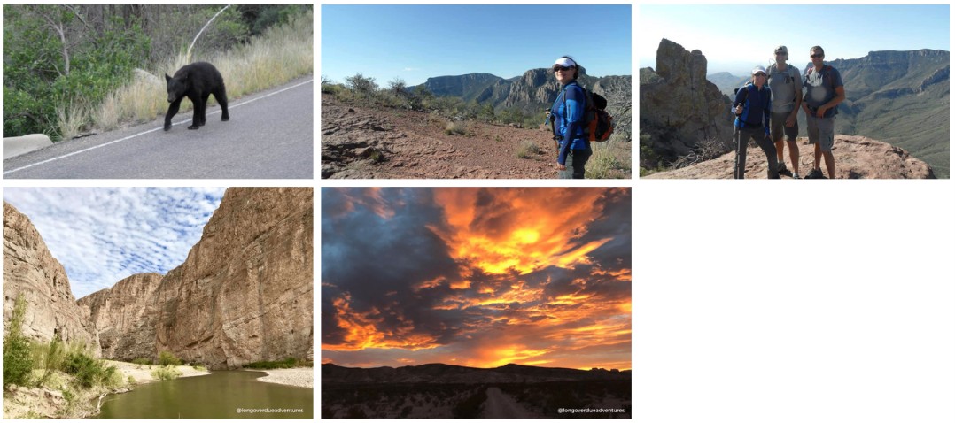
There’s an abundance of natural riches to explore inside the park and activities include hiking, rock climbing, mountain biking, wildlife viewing, stargazing, and even a day trip to sunny Mexico. Organized activities will get posted to the HTXO calendar as we get closer to the trip date and we’ll also have signup sheets available for each day’s activities, the night before.
Big Bend National Park encompasses more than 800,000 acres in southwest Texas. For more than 1,000 miles, the Rio Grande forms the international boundary between Mexico and the United States; Big Bend National Park administers approximately one-quarter of that boundary. Within the 118 twisting miles that also define the park’s southern boundary, the river’s southeasterly flows change abruptly to the northeast and form the “big bend” of the Rio Grande.
We are camping in the group campground in the Chisos Basin. We will have restrooms and sinks in the group camping area. There are pay showers near the hot springs that you can use. It’s a 45 min drive from camp so we plan for a mid-week shower. Bring quarters for the showers!
If you are interested in receiving information and updates about this trip, >>CLICK HERE<<
We will hold an in-person info meeting before the Trip. Until its date is communicated, you can watch an old replay of the info meeting. Everything is the same except dates, and I think the bathrooms are closed now, so expect to bring all of your own water. There should be a porta potty. There is NO electricity now either. They took out the bathroom outlets. Watch the replay here.
Transportation:
Transportation will be by carpool. A pre-trip meeting will be posted about a month before the trip to allow people to arrange to carpool.
You can drive throughout the night on Tuesday to arrive Wednesday morning, start Tuesday night, and stop mid-way, or leave early Sunday morning to arrive by dinner.
Meals:
The trip cost includes all 11 meals (Wednesday Dinner – Sunday Breakfast). Meals will be prepared in a community kitchen at camp. Everyone will be asked to pitch in with meal preparation, cleaning, and camp duties. We will have a sign-up sheet at the pre-trip meeting for this purpose. Bring snacks if you want, and your own beverages.
Please add in the notes section with your RSVP if you have any dietary restrictions. We can accommodate gluten-free/vegetarian/vegan/etc diets upon request.
Dining and cooking gear (pots, etc.) will be provided. It’s BYOB for beverages. Tea and coffee will be provided.
Cost:
- $175 Members – Early Bird Special til Dec 10th
- $195 Members – Regular Price
- $150 – 2nd person
- $299 Non-Members – including 3 months of Membership
- No Dogs, No Kids.
Refund Policy:
- Before Jan 1, 2027 – 90%
- After Jan 1, 2027 – no refund unless we fill your spot, then 90%
HTXO is bringing:
- Food
- Camping Stoves & Propane
- Cooking Utensils and pots for cooking
- French Press for Coffee
You need to bring:
NOTE: There is no electricity or showers in the camping area. This is a tent-only camping trip. Please only bring 2-4 person tent sizes, as space is limited.
- Plate / Bowl / Silverware / cup – something to eat and drink with
- Tent / Sleeping Bag / Ground Pad (ask about borrowing) – No RV
- Pillow
- Headlamp or light source
- Camping Chair
- Beverages & cooler if needed (no glass, no styrofoam)
- Clothes – pack in layers. Shoes for hiking, shoes for camp
- Toiletries (wipes, toothbrush, toothpaste, lotion, towel)
- Sun Protection – hat, long sleeves & pants, sunscreen, sunglasses
- Bug Spray
- Additional snacks you might want
- Charger / Cables
- Games
- Water if you don’t want to drink the tap water from the park
- An ID card
- Your Passport / Visas – If you go to Mexico for the day, you need your passport to get back. Additionally, there is a border control spot on the way out, even if you didn’t leave the country
Bring your own plate / cup / eating utensils, plus something to carry your lunches in. We’ll make lunch in the morning and then head out for the day.
An air mattress or sleeping pad is highly recommended – the ground is hard out there, and earplugs too – those bears snore pretty loud in West Texas!
Bring your passport, if you have one. The automated border crossing is NOW OPEN into sunny Mexico. Take a day trip into the tiny Mexican town of Boquillas.
NOTE: Regardless of whether you go to Mexico or not, on the drive back, there is a border stop. If you’re here on a visa or green card/etc, please make sure you have your paperwork. Even if you have a US id.
Tentative Schedule:
Arrive Wednesday
If you arrive before dinner, plan to eat at the lodge or bring your own food for breakfast & lunch. Set up camp and walk around the basin. Group together as people arrive and do the Window Trail.
Window Trail
“Difficulty: Moderate; Distance, 5.6 miles round trip
Begin at the Chisos Basin Trailhead
This trail descends through Oak Creek Canyon to the Window pour-off, which frames panoramic desert vistas. During wetter periods,s Oak Creek may be flowing and must be crossed several times. Use caution on this trail: the top of the Window pour-off is Slickrock with no railings, and the return hike is uphill.”
Balance Rock or check out the Panther Junction Nature Walk
Thursday:
If you want to backpack South Rim 1 night, please reach out to Amy. Permits are first come at the park only.
Day Hike Option 1 – South Rim
Day Hike Option 2 – Emory Peak
Day Hike Option 3 – Lost Mines & Chisos Basin Loop
South Rim:
Difficulty: Strenuous; Distance 12-14.5 miles round trip
Begin at Basin Trailhead
This challenging trail is well worth the 2,000 foot gain, as midway is the stunning vistas from the South Rim. Ascend either the steeper Pinnacles or more gradual Laguna Meadows Trail. During Peregrine Falcon nesting season, the Northeast and Southeast portions of this trail are closed.
Emory Peak
Difficulty: Strenuous; Distance: 10.5 miles round trip
Begin at the Chisos Basin Trailhead
Ascend the forested Pinnacles trail for 3.5 miles to the Emory Peak trail junction (on your right). Then take the 1-mile spur trail to the peak, which has nice vistas along the way. The last quarter mile or so climbs steeply, and the last 25 feet require a scramble up an exposed rock face, but the 360° view from Emory Peak, the highest point in the park, is superb. The antenna and equipment are part of Big Bend’s two-way radio system.
Lost Mine Trail
Difficulty: Moderate; Distance: 4.8 miles round trip
Begin at mile 5.1 on the Basin Road, limited parking
This trail serves as an outstanding introduction to the flora and fauna of the Chisos Mountains. With limited time, hike to marker 10 (about 1 mile), where a saddle offers stunning views of Casa Grande and Juniper Canyon. The remainder of the trail climbs steeply in and out of juniper, oak, and pine forest. The trail abruptly levels out at the ridge with superb views of Pine Canyon and the Sierra del Carmen in Mexico.
Chisos Basin Loop Trail
Difficulty: Moderate; Distance 1.8 miles round trip
Begin at the Chisos Basin Trailhead
The trail climbs gradually through shady stands of Mexican pine, oak, and juniper with many outstanding vistas of the window, and mountains surrounding the basin. Dense vegetation in the arroyos provides good habitat for bears and mountain lions; you may see tracks where they crossed the trail. Also, look for Mexican jays in the pines, and hummingbirds and Scott’s orioles in the agaves when in bloom. Though this loop trail may be done in either direction, following it counterclockwise is the easiest.
Friday:
Option 1 – Boquillas Canyon Trail, Mexico, Hot Springs Historic Trail, Shower!
Option 2 – Ernst Tinaja, Hot Springs Historic Trail, Rio Grande Trail. Shower!
Boquillas Canyon Trail
Difficulty: Moderate; Distance: 1.4 miles round trip
Begins at the end of the Boquillas Canyon Spur Road
The Boquillas Canyon trail climbs from the parking to the top of a cliff overlooking the Rio Grande. On this bluff, mortar holes from ancient inhabitants can be seen. Continue down to the river’s edge and into the canyon until the canyon walls meet the river. Sandy slopes in the canyon are fun for children.
Hot Springs Historic Trail
Difficulty: Easy; Distance: 1-mile round trip
Begin at Hot Springs parking lot
This trail pass remains of a resort, pictographs, homestead, and hot springs; a brochure at the trailhead offers more information. The 105°F springs are a popular destination (0.5-mile roundtrip), but one can continue to where the trail forks, leading to the top of the bluff and back to the parking lot.
Hot Springs Canyon Trail
Difficulty: Moderate; Distance: 6 miles round trip
Begin at Daniel’s Ranch or Hot Springs
This 3-mile trail (in either direction) connects Daniel’s Ranch and the Hot Springs. In places, it runs close to the river; in other areas along the rim of Hot Springs Canyon. This trail offers beautiful views of the Rio Grande, Chisos Mountains, and Del Carmen Mountains. No shade makes this trail a challenge in the summer heat.
Saturday:
Santa Elena Canyon Trail, Terlingua, Other desert trails.
Santa Elena Canyon Trail
Difficulty: Moderate; Distance: 1.7 miles round trip
Begins at the terminus of the Ross Maxwell Scenic Drive
This trail leads into the stunning Santa Elena Canyon. After crossing Terlingua Creek, the trail ascends on paved steps to a vista, then descends back to the water’s edge, continuing into the canyon until the canyon walls meet the water. A Big Bend classic. The trail is impassable when Terlingua Creek floods.
Please note: There is an extreme water shortage in the park. Please bring your own drinking water.
#bigbend #nps #campingintexas #hikingintexas
How to find us:
If you arrive early, people like to check out Panther Junction, the window 5.5miles, or Balanced Rock (aka Grapevine). Balance rock might be really hot in the afternoon.
Don’t forgot
* plate/bowl/cup/utensils
* pillow
* toiletries
* sleeping bag or blankets.
* power banks, no electricity here. You can also charge in the car on the way to some hikes.
Verizon has reception; not sure of others.
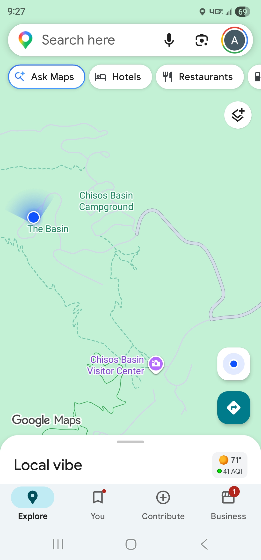
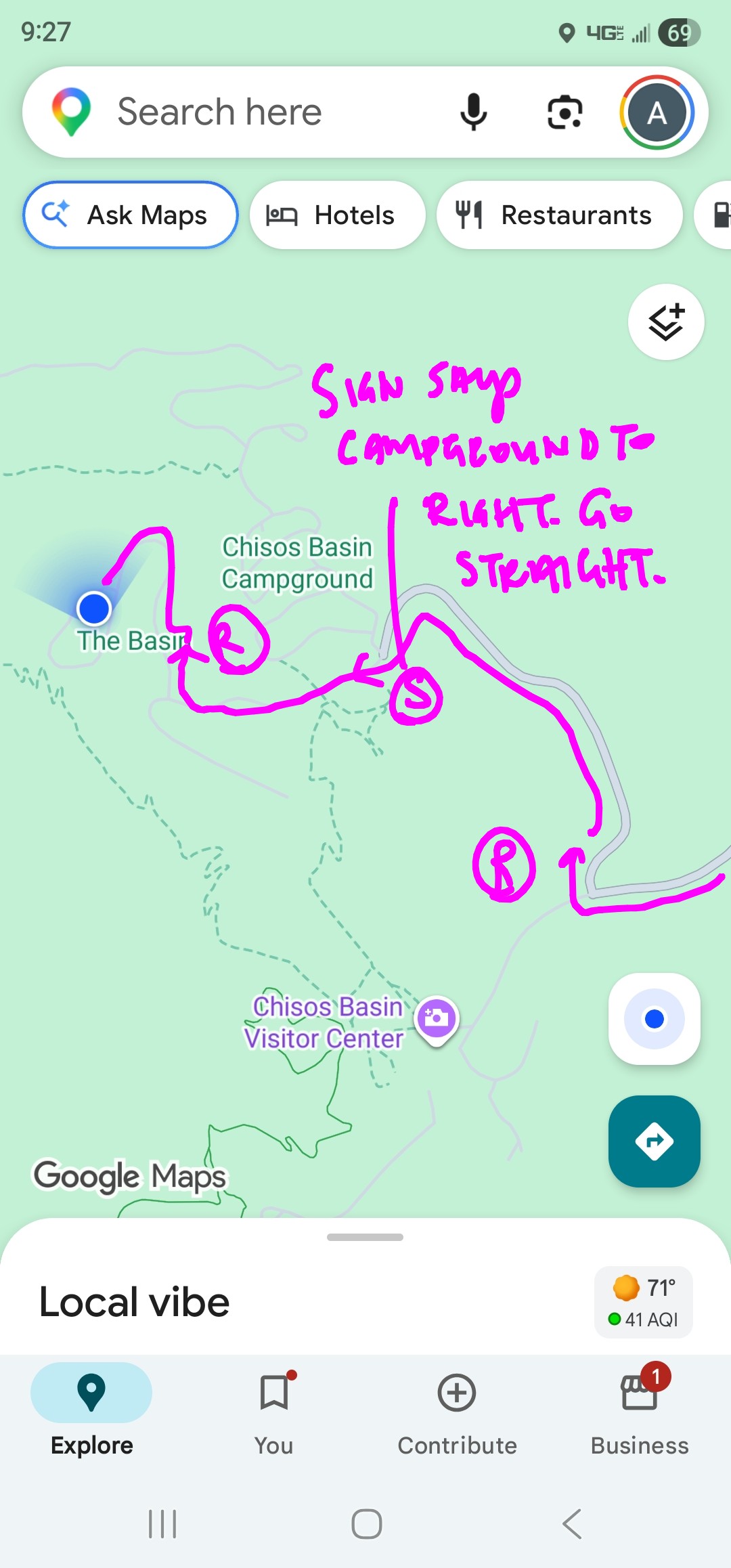
Directions: head towards the Lodge, Chisos Basin. Follow campground signs until the pic I showed you. Go straight at the sign. Then right at the next campground sign.
https://maps.app.goo.gl/21623Ap1pg1TqqSU6
https://maps.app.goo.gl/RAzBg3KguQiAS3xp8
Event Date & Time:
- Date: February 10, 2027 - February 14, 2027
Time: 2:00 pm - 1:00 pm
Add to calendar
Location
Venue: Big Bend National Park
Venue Website: https://www.nps.gov/bibe/index.htm?htxoutdoors
Address:Event Leader
-
Amy Hope

Phone: 210-504-8333
Email: amyhope@htxoutdoors.com
RSVP List
 Amy
Amy
To cancel your RSVP, please go to the "My Events" page.